News
Fabled Copper reports on the Magnum Mine Deposit UAV Drone Mission Survey
March 16, 2022
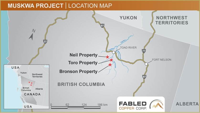
Vancouver, British Columbia – Fabled Copper Corp. (“Fabled Copper” or the “Company”) (CSE: FABL; FSE: XZ7) announces the 10th set of results of 2021 surface field work on it’s Muskwa Copper Project comprised of the Neil Property and the Toro Property in Northwestern British Columbia. The Company also holds rights to the Bronson Property. See Figure 1 below.
Figure 1 – Location Map
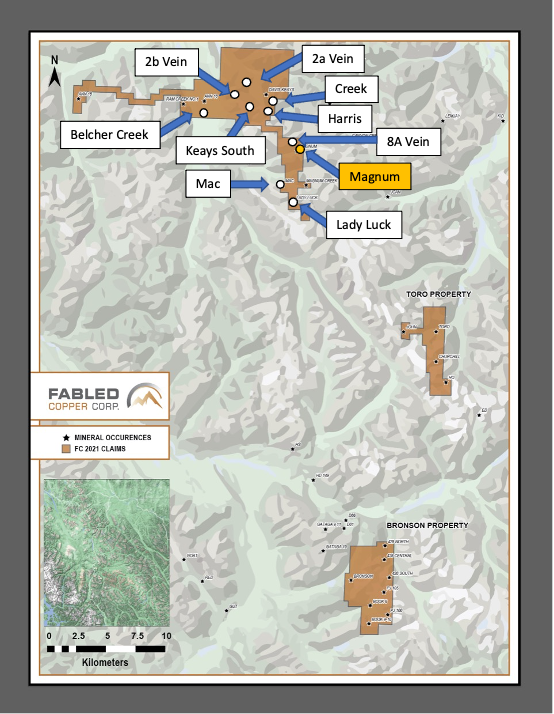
Peter Hawley, President, CEO reports; A total of 19 specific areas were mapped and prospected during the 2021 field season. We have previously reported our findings on the Lady Luck occurrence in the south end of the Neil Property, followed by the Mac; the 8A, Harris, the 2a and 2b, the Creek, Keays south, and Belcher Creek. We now turn our attention to the Magnum Mine copper deposit.” See Figure 2 below.
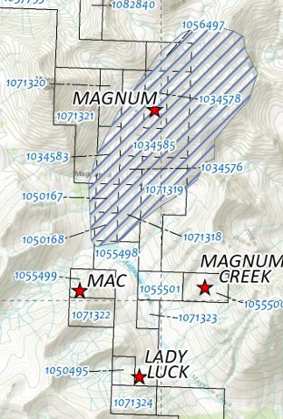
Figure 2- Neil Property, Magnum Mine Copper Deposit Location
Mineralization at the Magnum deposit consists of varying proportions of ankerite,
quartz, chalcopyrite, and pyrite, in partly replaced remnants of the sedimentary host rock
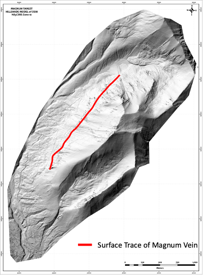
To date a total of ten veins have been identified, varying in width from less than 3 feet (0.9 meters)
up to 25 feet (7.6 meters), showing continuity on strike and at depth. The main developed veins are nearly vertical. See Photo 1 below.
The Magnum vein trend is also defined by a Versatile Time Domain Electromagnetic (VTEM) geophysical signature. See Figure 3 below.
Photo 1 – Surface Expression of Magnum vein, Neil Property
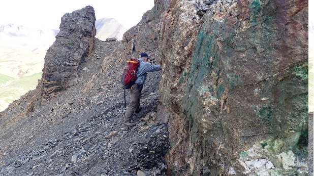
Figure 3 – Magnum Vein VTEM Signature
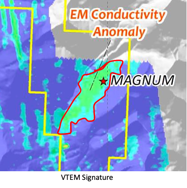
Figure 4 - UAV Drone Survey Area
As part of the 2021 exploration 5 selected areas were surveyed by an Unmanned Aerial Vehicle (UAV). A photogrammetry survey was conducted over the Harris, Eagle, Neil and Magnum veins by Drone North, See Figure 4 above for Magnum survey area.
The purpose of the UAV photogrammetry surveys were to:
(i) Generate high resolution photogrammetry datasets for the vein target to better
understand bedrock controls on copper mineralization.
(ii) Generate high resolution Digital Terrain Models (DTMs) to assist with 3D modelling of
the targets.
(iii) Generate baseline imagery to record current state of surface disturbance at sites that
will be actively explored in coming years.
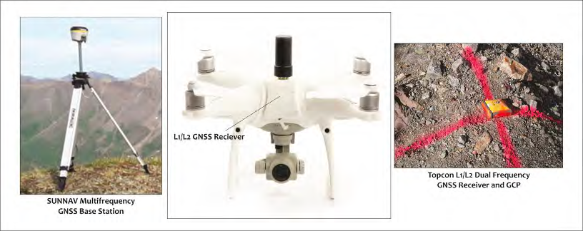
Equipment used to carry out UAV photogrammetry surveys consisted of a DJI Phantom 4 Pro v2.0 optical 20 megapixel camera drone with both a mechanical shutter and an upgraded rover L1/L2 Global Navigation Satellite System (GNSS) receiver. A multi - frequency Sunnav G10 base station was set to allow for PPK corrections of the UAV rover receiver location information. See Figure 5 below.
Figure 5 - UAV Drone Survey Area
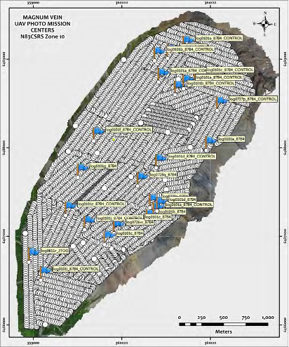
Ground control point (GCP) data was acquired during surveying. Twenty-five terrain-following missions were completed to survey the Magnum target with a total of 5,419 photographs acquired during surveying, and the final GSD`s (resolution) were 4.55 cm for theorthomosaic and 18.2 cm for the digital surface model (DSM).
Figure 6- UAV Magnum Mine Survey Data Points
Data products generated include 3-23 cm resolution colour orthophoto mosaics, Digital
Surface Models (DSM) and Digital Terrain Models (DTM). Hillshade models were also generated for
each target area. Survey grade accuracy (1-3 cm) ground control point data was also acquired at the
time of the UAV survey. See Figures 7, 8 below.
Figure 7- Color Orthophoto Digital Model
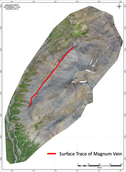
Figure 8- Hill Shade Digital Model
Press link here to view drone flight mission
Figure 9 – Blow Up of Copper Mineralization on Magnum Deposit
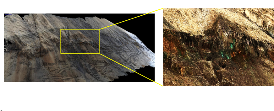
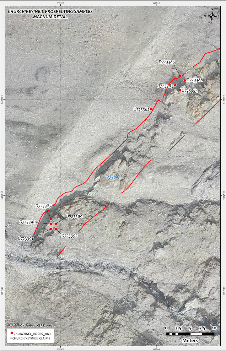
Figure 10- 2021 Magnum Sample Locations Plotted On 3-D Tilt Digital, Red Line Vein Trace
In addition, using various filter parameters the UAV drone survey area was evaluated for silica occurrences such as quartz which hosts the Magnum deposit. This survey showed very strong silica anomalies on the other side of the mountain which hosts the Magnum deposit and this will be followed up in the 2022 field season
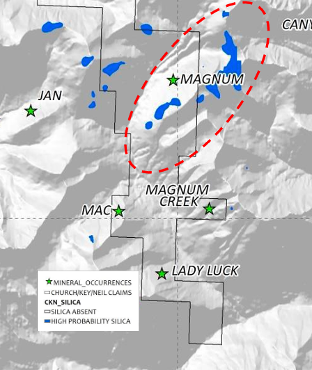
Figure 11 - Magnum Silica Alteration Locations
Going Forwards
Using the results of the data gathered by the UAV drone in the 2021 field season the field crew will further sample in detail and map the Magnum deposit in addition to traversing the southeast side of the hill side to investigate the silica anomalies.
An additional release on the sampling and results of the Magnum deposit will be forth coming in the following weeks.
About Fabled Copper Corp.
Fabled Copper is a junior mining exploration company. Its current focus is to creating value for stakeholders through the exploration and development of its existing copper properties located in northern British Columbia. The Muskwa Project comprises a total of 76 claims in two non-contiguous blocks and totals approximately 8,064.9 hectares, located in the Liard Mining Division in northern British Columbia.
Mr. Peter J. Hawley, President and C.E.O.
Fabled Copper Corp.
Phone: (819) 316-0919
For further information please contact:
The technical information contained in this news release has been approved by Peter J. Hawley, P.Geo. President and C.E.O. of Fabled, who is a Qualified Person as defined in National Instrument 43-101 - Standards of Disclosure for Mineral Projects.
The Canadian Securities Exchange does not accept responsibility for the adequacy or accuracy of this release.
Certain statements contained in this news release constitute "forward-looking information" as such term is used in applicable Canadian securities laws. Forward-looking information is based on plans, expectations and estimates of management at the date the information is provided and is subject to certain factors and assumptions, including, that the Company's financial condition and development plans do not change as a result of unforeseen events and that the Company obtains any required regulatory approvals.
Forward-looking information is subject to a variety of risks and uncertainties and other factors that could cause plans, estimates and actual results to vary materially from those projected in such forward-looking information. Some of the risks and other factors that could cause results to differ materially from those expressed in the forward-looking statements include, but are not limited to: impacts from the coronavirus or other epidemics, general economic conditions in Canada, the United States and globally; industry conditions, including fluctuations in commodity prices; governmental regulation of the mining industry, including environmental regulation; geological, technical and drilling problems; unanticipated operating events; competition for and/or inability to retain drilling rigs and other services; the availability of capital on acceptable terms; the need to obtain required approvals from regulatory authorities; stock market volatility; volatility in market prices for commodities; liabilities inherent in mining operations; changes in tax laws and incentive programs relating to the mining industry; as well as the other risks and uncertainties applicable to the Company as set forth in the Company's continuous disclosure filings filed under the Company's profile at www.sedar.com. The Company undertakes no obligation to update these forward-looking statements, other than as required by applicable law.